In a bold step toward advancing our understanding of Earth’s climate systems, a groundbreaking radar satellite equipped with a massive “umbrella-like” antenna has been successfully launched into space. This state-of-the-art technology, developed through international collaboration, promises to transform climate research by providing unprecedented insights into Earth’s water cycle, land movements, and weather patterns.
A Game-Changer for Climate Observation
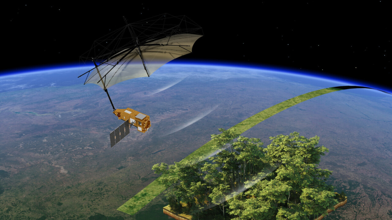
The satellite, part of a joint mission between NASA and the Japan Aerospace Exploration Agency (JAXA), carries a Synthetic Aperture Radar (SAR) system mounted on a deployable reflector that spans more than 12 meters when fully extended—hence the nickname “radar umbrella.” Once in orbit, the satellite’s large radar dish unfurled like a giant umbrella, enabling it to scan Earth’s surface with remarkable precision.
Unlike optical instruments that rely on clear skies, radar systems can penetrate cloud cover, operate day and night, and detect minute changes in surface conditions. This makes them invaluable for monitoring climate-related phenomena such as soil moisture, glacier movement, deforestation, and urban expansion.
Filling Critical Data Gaps
One of the major challenges in climate science has been the lack of consistent, high-resolution global data. This radar satellite aims to fill those gaps by continuously collecting data on Earth’s surface changes. It can detect millimeter-level movements of land masses, track flooding patterns in near real-time, and assess vegetation health across vast regions.
By observing how water moves through the environment—from rainfall to rivers, aquifers, and oceans—the satellite provides scientists with the tools needed to understand how climate change is impacting ecosystems and human settlements.
Supporting Climate Resilience and Disaster Response
The real-time data from the radar satellite will also enhance disaster response capabilities. Emergency teams will be able to use the information to predict landslides, track the progression of hurricanes, and assess earthquake-affected areas. In addition, agricultural planners and water resource managers will benefit from better forecasting tools to adapt to a warming world.
This mission is especially timely as extreme weather events become more frequent and severe. The ability to monitor Earth’s changes in near real-time is no longer a luxury—it’s a necessity for global resilience.
A Technological Marvel
The satellite’s radar system uses L-band frequencies, which are particularly effective at penetrating dense vegetation and soil. This allows the system to “see” beneath forest canopies and track hidden geological processes. Its large antenna—made from a lightweight mesh stretched over collapsible supports—was engineered to withstand the harsh environment of space while maintaining the precision needed for scientific observation.
Deploying such a structure in space posed significant engineering challenges. However, thanks to years of research and successful test deployments, the radar umbrella unfurled flawlessly, marking a milestone in space-based Earth observation technology.
Looking Ahead
As the satellite begins its operational phase, scientists around the world are preparing to integrate its data into climate models and environmental studies. The mission is expected to last at least three years, but its impact on climate science could resonate for decades.
In an era where climate misinformation and political polarization threaten progress, this radar umbrella stands as a symbol of international cooperation and scientific ambition. It reminds us that the tools to understand and address climate change are within reach—we just need to deploy them.